High School Hill Gallery
Pictures of, from, or near High School Hill.
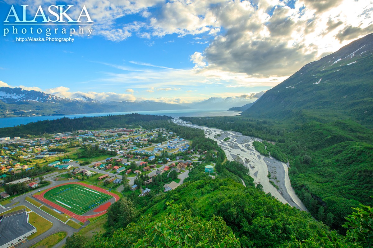
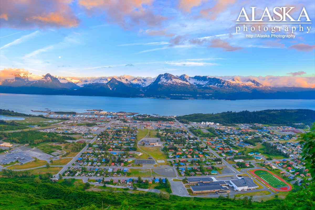
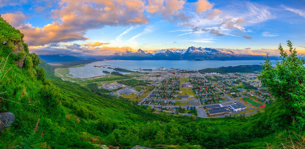
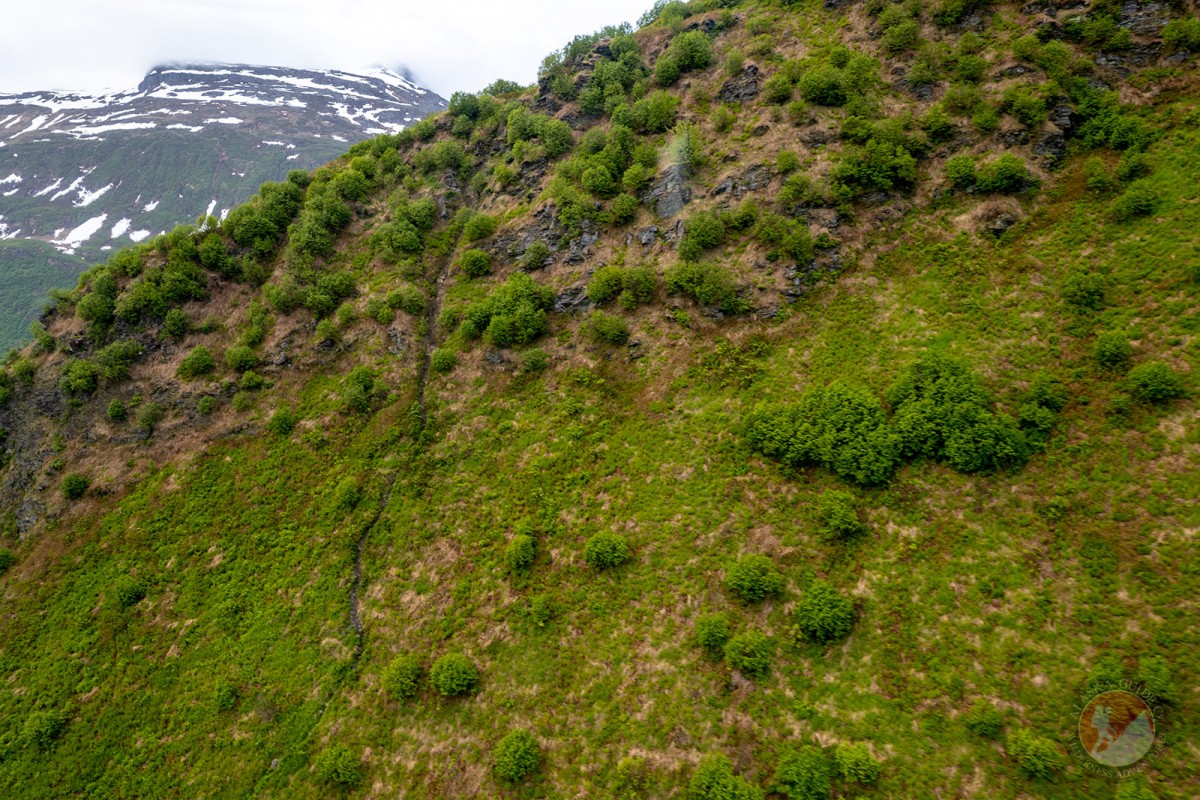
High School Hill in Valdez is in one word. Steep. If you're attacking it from the face, the high school parking lot trail head it's typically a 40° + climb, with nothing that really qualifies as a switchback. For people looking for a milder ascent there is a trail that begins behind the water tower at the beginning of the Mineral Creek Rd (trail description further down). Our recommendation is don't hike High School Hill if it has been raining.
High School Hill is good challenge for anyone. Most ascents to the lookout rock on the top of the ridge take 30-40 mins by our lead hiker. Some do it in less, and some turn back... It's roughly 1300ft of trail gaining 900ft elevation. The last couple hundred feet of the trail is a rope assisted scramble. Bring gloves if you want to keep your hands clean. Majority of dogs can not make this portion of the hike.
Most people stop their climb at the ridge/lookout rock. However for those looking to summit. High School Hill trail does continue through the alders, up into the alpine, and a steady ascent up along the ridge to the top. The trail no matter where you stop is by far an amazing view and the best views of Valdez you can get from any trail or spot on the ground.
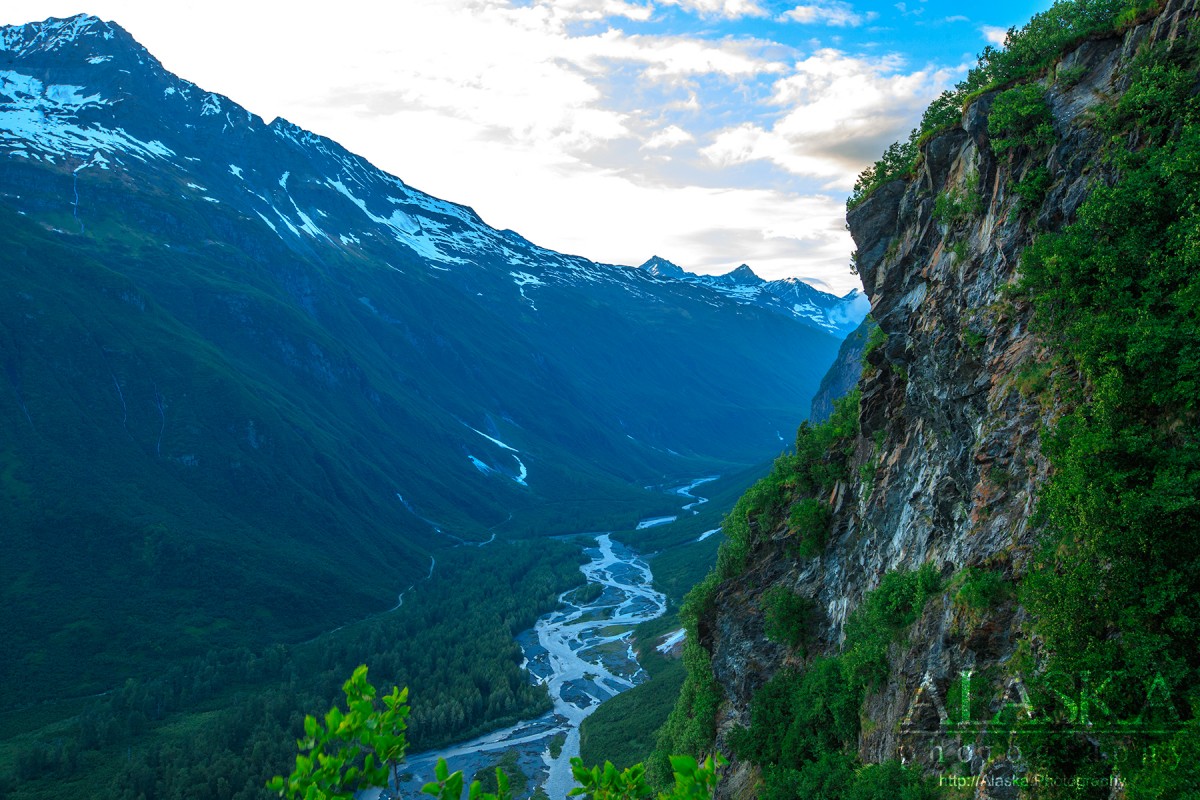
The back side (side facing Mineral Creek) is cliffs and very steep terrain beware not to venture too far over the ridge.
High School Hill - Water Tower Trail
The water tower trail is best for anyone attempting the hike with younger experienced children or anyone hiking with a dog. While it is an option most of the trail is walking through 4ft tall salmonberries. Many tourist get lost taking this route and generally a couple times a year search and rescue is called in to get them down.
This portion is more mild but still includes rope assisted sections and exposure to areas that could lead to serious injury.
To get to the main High School Hill trail head park in the east side of the Valdez High School parking lot.
To get to the High School Hill - Water Tower Trail take Egan Ave, turn towards the hill on Hazelet Ave, then left on to Hagnita St, and right on to Mineral Creek Drive. Park on the shoulder where the pavement ends. Hike up to the water tower and there is a tunnel trail into the alders, on the town side of the water tower.
High School Hill is aptly named as it begins in the high school parking lot and continues up the hill side behind the high school. Not much in known as to when the trail was officially set or named.
Anderson Bay, The Lagoon, Port Valdez,
Capes:Allison Point, Dock Point, Jackson Point,
Caves:Cities:Crags:Valdez Glacier Campground Wall, Lookout Rock, Panorama Point,
Dams:Solomon Gulch Dam A, Solomon Gulch Dam B, Solomon Lake Dam,
Flats:Glaciers:Glacier G213478E61182N, Allison Glacier, Area 51 Glacier, Glacier G213498E61160N, Glacier G213500E61175N, Glacier G213550E61021N, Glacier G213583E61167N, Glacier G213585E61165N, Glacier G213585E61165N, Glacier G213602E61200N, Glacier G213603E61218N, Glacier G213614E61180N, Glacier G213653E61264N, Glacier G213685E61168N, Glacier G213687E60954N, Glacier G213708E60993N, Glacier G213722E60985N, Glacier G213723E61170N, Glacier G213727E61240N, Glacier G213737E60948N, Glacier G213739E61247N, Glacier G213740E61167N, Glacier G213742E61233N, Glacier G213749E60966N, Glacier G213750E61221N, Glacier G213756E61212N, Glacier G213756E61263N, Glacier G213767E61200N, Glacier G213767E61245N, Glacier G213770E61226N, Glacier G213775E60940N, Glacier G213777E61166N, Glacier G213778E61174N, Glacier G213780E61222N, Glacier G213780E61222N, Glacier G213783E60980N, Glacier G213784E61033N, Glacier G213788E60991N, Glacier G213798E61012N, Glacier G213804E61037N, Glacier G213821E60955N, Glacier G213835E60986N, Glacier G213860E61028N, G-g-g-g-g Glacier, Johnson Glacier, Kate Glacier, Mineral Creek Glacier, Salmon Creek Glacier, Shoup Glacier, Valdez Glacier,
Hills:Routes:Blue Horizons, Excalibur, Gravy Tran, Kayaker's Delight, Necromancer, Peggy's Mane, Wowie Zowie,
Islands:Ammunition Island, Mineral Creek Islands,
Lakes:Allison Lake, Silver Lake, Solomon Gulch Lake, Solomon Lake, Solomon Lake, Valdez Glacier Lake,
Locales:Airport Chute, Alaska Guide Company - Office, Area 51, Basin Cove, Cabell Chute, Chuck Chute, Chuck Junior, Delta Chute, Grant Chute, Jago Chute, Lookout Bowl, Lucky 13, Runner's Delight, Sentinel, Sheepshead Chute, Tombstone Wall,
Mine:Big Four Mine, Cash Mine, Giant Mine, Hercules Mine, Johnson Mine, Midas Mine,
Mountains:Mount Francis, Mount Kate, Mount Logan, Mount Hogan, Mummy Mountain, Mount Schrader, Mount Shasta, Mount Shouplina, Sugarloaf Mountain, Townsend Peak, Valdez Summit, West Peak,
Peaks:Benzene, Bob's Knob, Comstock, Embick, High Back, Mile High Peak, Snow Dome, Titan Chair,
Rivers:Duck River, Lowe River, Robe River,
Routes:Lazy Days, No Floss Necessary, Route number 1, Route number 3, Trim the Bush, Wet Finish,
Routes:Already Herd, Bicentennial, Bongo That Bitch, Brand New, Canadian Heat Wave, Cotter Unlimited, Danger Stranger, Dragon's Teeth, Dynosaur, The Firing Line, Gusel Jugs, Harristotle, Kentner's Mill, Leaf BlowersL, Ledgeway to Sleven, Lefty Lucy, People Get Up And Drive Your Funky Soul, Quartzsite's Strike, Reacharound, Redheaded Stepchild, Righty Tighty, Route number 2, Slabawooke, The Nose Knows, Your Favorite Weapon,
Streams:Abercrombie Creek, Allison Creek, Brevier Creek, Camicia Creek, Corbin Creek, Crooked Creek, Dayville Creek, East Fork Mineral Creek, Glacier Creek, Gold Creek, Horsetail Creek, Mineral Creek, Salmon Creek, Sawmill Creek, Slater Creek, Valdez Glacier Stream, Wood Creek,
Routes:Area 51 Access Trail, Dayville Power Line Trail, Dock Point Trail, East Peak Access Trail, Mount Francis Winter Trail, High School Hill, High School Hill to Summit Trail, High School Hill Water Tower Trail, Hogsback Trail, Homestead Trail, John Hunter Memorial Trail, Levee to Valdez Glacier Trail, Lost Toque Trail, Mineral Creek East Trail, Mineral Creek Stamp Mill Trail, Mineral Creek West Trail, Northern Robe Lake Trail, River Drive Trail, Robe River Hogsback Access Trail, Shoup Bay Trail, Solomon Gulch Valdez Overlook Spur, Southern Robe Lake Trail, Valdez Bike Path, Valdez Overlook Trail,
Valleys:Abercrombie Gulch, Solomon Gulch, Sulphide Gulch,
Cities:Pictures of, from, or near High School Hill.