Townsend Peak Gallery
Pictures of, from, or near Townsend Peak.
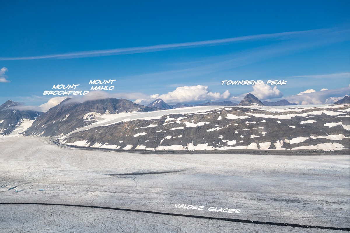
At the junction of the Valdez and Kutina Glaciers, 17 mi. E of Mount Mahlo, 17 mi NNE of Valez, Chugach Mountains.
Named for L. E. Nielsen in 1960 for Dr. Leroy S. Townsend, physician at Copper Center during the winter of 1898-1899 and author of a report on scurvy suffered by the prospectors in the area that winter.
Valdez Glacier Campground Wall, Lookout Rock, Panorama Point,
Glaciers:Abercrombie Shelf Glacier, Camicia Glacier, Glacier G213583E61167N, Glacier G213585E61165N, Glacier G213585E61165N, Glacier G213594E61501N, Glacier G213602E61200N, Glacier G213603E61218N, Glacier G213606E61497N, Glacier G213608E61504N, Glacier G213614E61180N, Glacier G213615E61514N, Glacier G213625E61511N, Glacier G213653E61264N, Glacier G213685E61168N, Glacier G213723E61170N, Glacier G213727E61240N, Glacier G213739E61247N, Glacier G213740E61167N, Glacier G213742E61233N, Glacier G213750E61221N, Glacier G213756E61212N, Glacier G213756E61263N, Glacier G213763E61411N, Glacier G213767E61200N, Glacier G213767E61245N, Glacier G213768E61385N, Glacier G213770E61226N, Glacier G213777E61166N, Glacier G213778E61174N, Glacier G213780E61222N, Glacier G213780E61222N, Glacier G213781E61419N, Glacier G213790E61394N, Glacier G213802E61478N, Glacier G213808E61415N, Glacier G213811E61486N, Glacier G213815E61401N, Glacier G213822E61414N, Glacier G213822E61478N, Glacier G213822E61486N, Glacier G213881E61189N, Glacier G213883E61190N, Glacier G213898E61187N, Glacier G213910E61368N, Glacier G213914E61380N, Glacier G213925E61388N, Glacier G213927E61398N, Glacier G213934E61146N, Glacier G213935E61200N, Glacier G213952E61151N, Glacier G213956E61364N, Glacier G213959E61371N, Glacier G213959E61389N, Glacier G213964E61199N, Glacier G213979E61354N, Glacier G213981E61263N, G-g-g-g-g Glacier, Johnson Glacier, Klutina Glacier, Mineral Creek Glacier, Stephens Glacier, Valdez Glacier,
Hills:Routes:Blue Horizons, Diamond in the Sky, Excalibur, Gravy Tran, Kayaker's Delight, Peggy's Mane, Wowie Zowie,
Lakes:Locales:Airport Chute, Cabell Chute, Chuck Chute, Chuck Junior, Delta Chute, Grant Chute, Jago Chute, Lookout Bowl, Lucky 13, Runner's Delight, Sentinel, Sheepshead Chute,
Mine:Big Four Mine, Cash Mine, Giant Mine, Hercules Mine, Johnson Mine,
Mountains:Prospectors Peak, Abercrombie Mountain, Mount Brookfield, Camp Mountain, East Peak, Mount Evans, Garrett Peak, Mount Logan, Mount Mahlo, Mayer Peak, Mount Ourand, Mount Schrader, Sharp Peak, Townsend Peak, Valdez Summit, West Peak,
Peaks:Mount Bonet, High Back, Mile High Peak, Titan Chair,
Routes:Lazy Days, No Floss Necessary, Route number 1, Route number 3, Trim the Bush, Wet Finish,
Routes:Already Herd, Bicentennial, Bongo That Bitch, Brand New, Canadian Heat Wave, Cotter Unlimited, Danger Stranger, Dragon's Teeth, Dynosaur, The Firing Line, Gusel Jugs, Harristotle, Kentner's Mill, Leaf BlowersL, Ledgeway to Sleven, Lefty Lucy, People Get Up And Drive Your Funky Soul, Quartzsite's Strike, Reacharound, Redheaded Stepchild, Righty Tighty, Route number 2, Slabawooke, The Nose Knows, Your Favorite Weapon,
Streams:Brevier Creek, Camicia Creek, East Fork Mineral Creek, Glacier Creek, Horsetail Creek, Stephens Creek, Wood Creek,
Routes:High School Hill, High School Hill to Summit Trail, High School Hill Water Tower Trail, Lost Toque Trail, Mineral Creek Stamp Mill Trail,
Pictures of, from, or near Townsend Peak.