Brooks Range Gallery
Pictures of, from, or near Brooks Range.
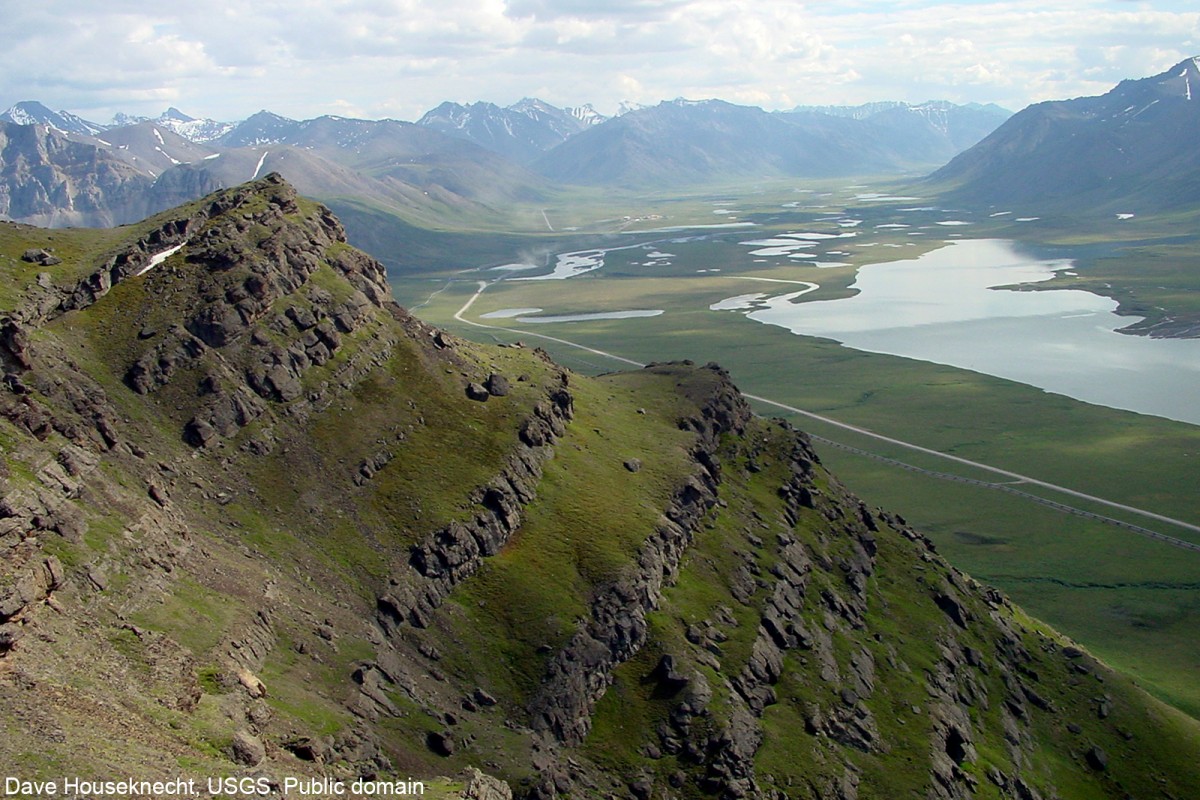
Incomplete record. Mountain range, 4,000-9000 ft., extends E-W about 600 mi. from Canada on E to Chukchi Sea on W and forms the divide between Arctic Slope drainage to N and Kobuk and Yukon Rivers to S. Mount Isto is the highest point.
Named in 1925 by the U.S. Geological Survey (USGS) for Alfred Hulse Brooks, 1871-1924, chief Alaskan geologist of the U.S. Geological Survey from July, 1903 to his death. Sir John Franklin, Royal Navy (RN), in 1826 called the range the "Rocky Mountains." In 1916 Brooks (1916b, p.252-253), U.S. Geological Survey (USGS), wrote "A new name, Arctic Mountain system, is proposed for the east and west trending mountain system of northern Alaska formerly regarded as part of the Rocky Mountain system. Recent investigations by Canadian and American geologists have shown that this is a distinct system from the Rocky Mountains." However, Wahrhaftig (1965, p.18), U.S. Geological Survey (USGS), places the Brooks Range in the Rocky Mountain system. This appears to be the range that Lieutenant P.H. Ray (1885, p.28), USA, referred to when he wrote: "From the break of the country, I have no doubt Meade River has its source in that range, so I named them 'Meade River Mountains.'" See Hooper Mountains.
Eagle Cliff, Howling Dog Rock, Inukpasuk Hill, Ponrakvirak Hill, Sivugak Hill,
Akillyik Mountain, Alhamblar Mountain, Als Mountain, Amawk Mountain, Amphitheatre Mountain, Apoon Mountain, Asbestos Mountain, Asik Mountain, Big Rock Mountain, Bismark Mountain, Blackface Mountain, Bluecloud Mountain, Boreal Mountain, Brushman Mountain, Buffalo Mountain, Burnt Mountain, Button Mountain, Chevron Hill, Coal Mountain, Cockedhat Mountain, Copter Peak, Cosmos Mountain, Crag Peak, Crow Nest Rock, Crystal Peak, Deadlock Mountain, Dusty Mountain, Ear Peak, East Buttons, Eekayruk Mountain, Ekakevik Mountain, Emma Dome, Eroded Mountain, Falsoola Mountain, Ferguson Peak, Foggytop Mountain, Fork Peak, Gilroy Mountain, Gray Mountain, Grotto Mountain, Hanging Glacier Mountain, Harvey Mountain, Horace Mountain, Iikhkluk Mountain, Ilaigutigrak Mountain, Inclined Mountain, Index Mountain, Inerevuk Mountain, Ipnek Mountain, Isikut Mountain, Jesse Mountain, Kaikshak Hill, Katiktak Mountain, Kaultui Mountain, Kavaksurak Mountain, Kaviktit Mountain, Keche Mountains, Kingak Cliff, Kingak Hill, Kivliktort Mountain, Koiyaktot Mountain, Kollutuk Mountain, Limestack Mountain, Little Brushman, Little Rock Mountain, Little Squaw Peak, Lois Dome, Marshmallow Mountain, Marten Stand Mountain, Mayukuit Mountain, McLellan Peak, Midnight Dome, Misty Mountain, Moving Mountain, Napaktualuit Mountain, Nasaurak Mountain, Niakogon Mountain, Nichenthraw Mountain, Nukatpiat Mountain, Okiotak Peak, Old John Mountain, Oolah Mountain, Oxadak Mountain, Paddle Mountain, Panapkagrak Mountain, Peter John Mountain, Pingaluligit Mountain, Poss Mountain, Rabbit Ears, Redstar Mountain, Rim Butte, Rock Head West, Rumbling Mountain, Salmon Mountain, Sapumegrak Mountain, Sapumim Neakau Mountain, Satsiksuk Mountain, Seven Dikes Mountain, Shark Edge Mountain, Shoulder Mountain, Shungnak Mountain, Siavlat Mountain, Sillyasheen Mountain, Sirr Mountain, Sivukat Mountain, Sixty-one Mountain, Smith Creek Dome, Snowden Mountain, Snowheel Mountain, Soakpak Mountain, Spike Mountain, Suloktingirak, Swan Mountain, Tetsyeh Mountain, Thazzik Mountain, Three River Mountain, Threetime Mountain, Tobin Mountain, Twelvemile Mountain, Twoday Mountain, Twoprong Mountain, Uchugrak Hills, Under Cloud Mountain, Vermont Dome, Vorzui Mountain, Water Creek Mountain, West Buttons, White Snow Mountain, Whiteface Mountain, Wiehl Mountain, Wien Mountain, Yasuda Mountain,
Akurekvik Pass, Delay Pass, Ernie Pass, Gates of the Arctic, Gull Pass, Holmes Pass, Howard Pass, Inyorurak Pass, Kinnorutin Pass, Linda Creek Pass, McLellan Pass, Nakmaktuak Pass, Naksrak Pass, Oolah Pass, Pasco Pass, Rosie Creek Pass, Sitkum Pass, Siwash Pass, Snowshoe Pass, Tobin Pass, Vermont Pass, Woodland Echo Pass,
Akiak Mountains, Akutagrak Hills, Baird Mountains, British Mountains, Davidson Mountains, Endicott Mountains, Franklin Mountains, Helpmejack Hills, Howard Hills, Isacheluich Mountains, Isahultila Mountains, Ivotuk Hills, Jack White Range, Kallarichuk Hills, Kingasivik Mountains, Kurupa Hills, Manuilyisat Hills, Mary Range, Nigu Hills, Ninemile Hills, Philip Smith Mountains, Pupik Hills, Romanzof Mountains, Sadlerochit Mountains, Third Range, Waring Mountains,
Akiknaak Peaks, Kelly Ridge, Kipaiak Ridge, Ottertail Ridge, Spiny Ridge, Sulungatak Ridge,
Inualurak Mountain, Invalurak Mountain, Nunamuit Mountain,
Mountain Ranges:Streams:Pictures of, from, or near Brooks Range.