Bullion Mountain Gallery
Pictures of, from, or near Bullion Mountain.
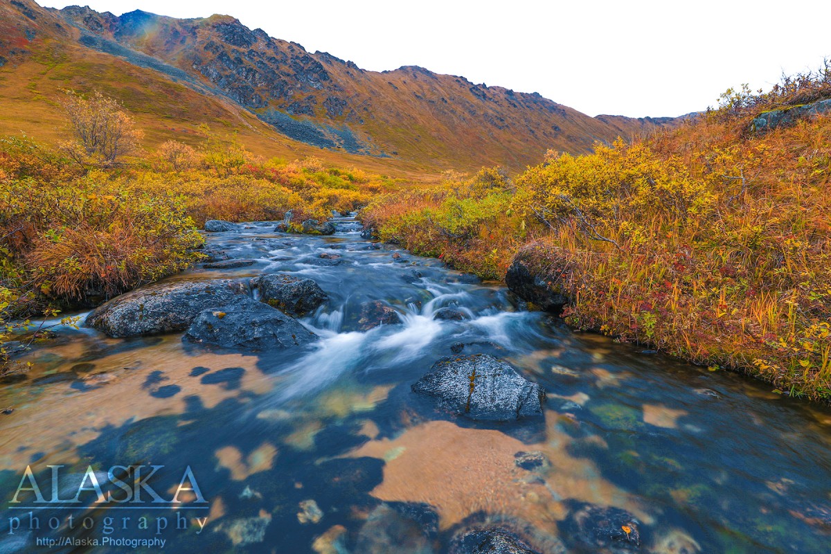
extends NE-SW 4 mi. between Craigie and Upper Willow Creeks, 14 mi. NW of Palmer, Talkeetna Mts.
Local name reported in 1951 by U.S. Geological Survey (USGS).
Independence Mine Dam, Memory Lake Estates Dam Number 1, Memory Lake Estates Dam Number 2,
Routes:Lakes:Anderson Lake, Baird Lake, Black Lake, Chignaki Pond, Clear Lake, Cornelius Lake, Cottonwood Lake, Dandy Lake, Dry Lake, Dusk Lake, Emerald Lake, Finger Lake, Gold Cord Lake, Gooding Lake, Hart Lake, High Ridge Lake, Jacobsen Lake, Kennedy Lake, Kings Lake, Lower Reed Lake, Lucile Lake, Meier Lake, Memory Lake, Mud Lake, Mud Lake, Mud Lake, Neklason Lake, Paradise Lake, Pinnacle Lake, Reed Lake, Summit Lake, Upper Reed Lake, Walby Lake, Wasilla Lake, Wolf Lake,
Locales:7 Sacred Chutes, April Bowl, Baby Ruth, Bennet's Ridge, Black Prospect, Eldorodo Bowl, Face of Hatch, Fairangel Cirque Gully, Farside, Gold Chord Death Traverse, Lake Run, Lake Run, Nixon's Nose, Nosebleed, Nunatak East, Nunatak West, Point 30, Rock Garden, Seldom Seen, Stairstep, Sunnyside, Sunnyside of Hatch, Swimmin' Tims, The Glades, The Lost Couloir, Valley of Sin, Wimp Bowl, Womens Run,
Mine:Arch Prospect, Black Prospect, Eldorado Mine, Fern Mine, Gold Bullion Mine, Gold Cord Mine, High Grade Mine, Holland Prospect, Independence Mine, Kelly-Willow Prospect, Lane Prospect, Lonesome Mine, Lucky Shot Mine, Mabel Mine, Marion Twin Mine, Martin Mine, Rae-Wallace Mine, Schroff-O-Neil Mine, Snowbird Mine, Talkeetna Mine, Thorpe Mine, War Baby Mine, Webfoot Prospect,
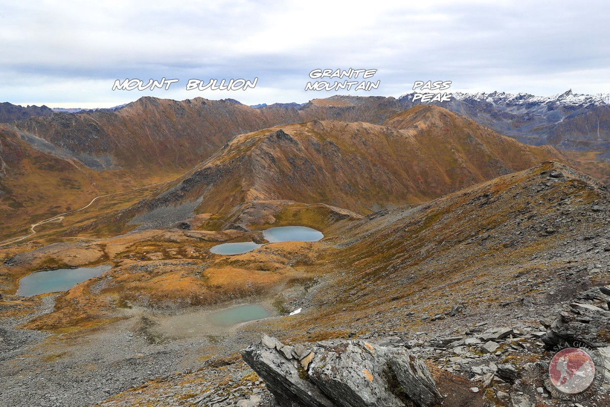
Mountains:Bald Mountain, Bullion Mountain, Government Peak, Idaho Peak, Marmot Mountain, Skyscraper Mountain,
Parks:Independence Mine State Historical Park, Finger Lake State Recreation Site, Wolf Lake State Recreation Site,
Mountain Passes:Birthday Pass, Dogsled Pass, Friendship Pass, Hatcher Pass, Point 40,
Peaks:Blueberry Knoll, Didikama, Fairangel Cirque, Fairangel Peak, Fish Peak, Gold Chord, Good Hope Towers, Granite Mountain, Hatch Peak, Higher Spire, Lower Spire, Luck Peak, Lynx Peak, Microdot, Nunatak, Outpost Peak, Parlimint, Pass Peak, The Pinnacle, Rae-Wallace, Rainy Day Knoll, Top Peak, Turnkey Peak, Yisbo,
Ridges:Bald Mountain Ridge, Murphy Ridge, President's Ridge,
Routes:Mile 16 Ski Run, Paradise Ski Run,
Streams:Archangel Creek, Bartholf Creek, Carnegie Creek, Coal Creek, Cottonwood Creek, Craigie Creek, Delia Creek, East Fork Fishhook Creek, East Fork Sawmill Creek, Fairangel Creek, Fishhook Creek, Francie Creek, Glacier Creek, Goodhope Creek, Government Creek, Grubstake Creek, Hatcher Creek, Homestake Creek, Moon Princess Creek, Reed Creek, Sawmill Creek, Shorty Creek, Sidney Creek, Upper Willow Creek, West Fork, West Fork Grubstake Creek, West Fork Sawmill Creek,
Routes:April Bowl Trail, Arch Prospect Trail, Assay Spur Trail, Blueberry Knoll Trail, Fairangel Trail, Gold Cord Lake Trail, Gold Mint Trail, Hard Rock 2 Trail, Hard Rock Trail, Hatcher Pass Snowmobile Trail, Hatcher Pass Snowmobile Trail 1, Hatcher Pass Snowmobile Trail 2, Hatcher Pass Winter Maintenance Trail, Independence Mine Trail, Lane Basin (Old Road) Trail, Lane Basin Trail, Marmot Mountain Trail, Martin Mill Trail, Mill Loop Trail, Rae-Wallace Mine Trail, Reed Lakes Trail, Snow Trail to Lodge, Snowbird Trail,
Valleys:Cable Valley, Grubstake Gulch, West Fork Grubstake Gulch, Wet Gulch,
Cities:Pictures of, from, or near Bullion Mountain.