Something for Everyone on the Valdez Pack Trail of 1899

By Allison Sayer | Published Oct 8, 2017

The Valdez Trail of 1899 is a gem, but I only rarely see other people on it. It takes you through a series of different ecosystems from mossy forest to alpine tundra. The trail is generally kept in very good shape, with just one real muddy spot towards the southern end. It also has historic significance. It follows the pack trail the Army Corps of Engineers built between 1899 and 1901 between the ocean and the interior. There are four trailheads along the Richardson Highway: at 12 mile, 14 mile, 20 mile, and 26 mile, giving hikers a range of options. Technically, the southern end is the "Pack Trail of 1899" and the northern end is the "Wagon Road of 1898," but it all feels like one trail to me.

The Trail by Section:

Trail head sign
Trail head sign
12 mile trailhead:

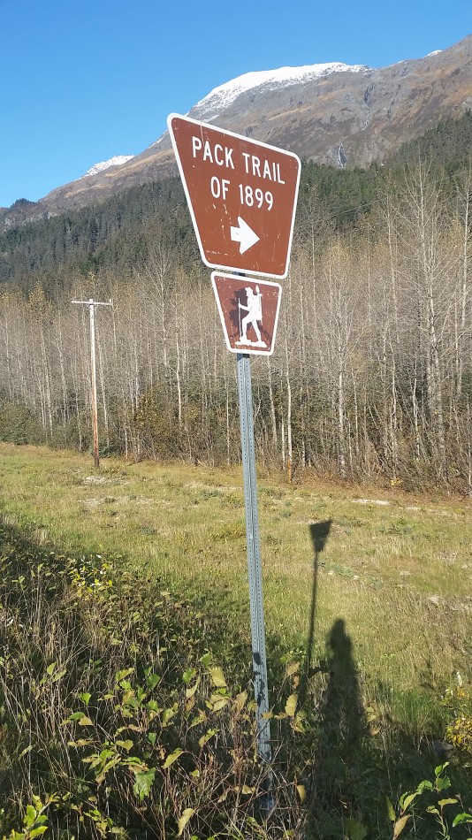
The southernmost trailhead is on a spur road just south of the 12-mile marker on the Richardson Highway. There is a brown "Pack Trail of 1899" sign marking the road, on the left side of the highway if you are driving away from town. Shortly after the turn, there is a small pullout across from a stream. There is a very well-travelled social trail right at the stream that dead ends shortly. The trail is several yards down the road, on the left as you are heading away from the highway. It has a small sign that says "Trail."

Hazards: black bears, some muddy sections, some exposure.

The trail starts in a lush forest. There are large spruce trees, watermelon berries, blueberry bushes, soft mosses, and beautiful little streams. This area is a good place to forage for fiddleheads in the spring, and in the summer the profusion of ferns gives the area a prehistoric feel.

This section of trail features many interpretive signs that are genuinely interesting. One sign helps viewers to spot original pieces of trail construction from over 100 years ago. Others contain original accounts of people's experiences in the early twentieth century.

After a few switchbacks, the trail plateaus. As Keystone Canyon comes into view, the hillside drops off steeply just off the trail, creating some exposure. It is easy to imagine this would be extremely difficult for travelers with fully loaded horses.

Once the trail is in Keystone Canyon, it offers terrific views. You can see much higher up Bridal Veil Falls from the trail than you can from the highway. You can also watch kayakers and rafters float down the Lowe River. Behind you, there is a view of the Lowe River. and Meteorite Mountain.

A steep spur trail leads downhill to the Keystone Canyon trailhead, while the main trail continues onwards.

Keystone Canyon (14 mile) trailhead:

The Keystone Canyon trailhead is very difficult to see while driving, but the pullout is unmistakable. The trailhead is located between the Bridal Veil Falls pullout and Horsetail Falls, just south of mile 14. Park in the large pullout on the west side of the road used to view Bridal Veil Falls. At the southern end of the pull out there is an interpretive sign describing the "Goat Trail." Right at the sign, a path leads through the vegetation parallel to the highway to the south. Just before the rocky cliff, the trail turns away from the highway to the right and climbs uphill.

Hazards: black bears, some slippery steep spots on the spur trail between the trailhead and the main trail, wet feet at one stream

This section of the trail is solidly in the transition zone between the lush rainforest at 12 mile and the true alpine tundra at 25 mile. There is not much here for foragers, but there are some good views of the surrounding mountains and some pretty streams running down the canyon sides. The vegetation is mostly alder.

After passing Keystone Canyon, the trail stays on the mountainsides. The biggest highlight of this section is a rocky stream coming down from an alpine waterfall. If you wish to continue along the trail after this point, you need to cross the stream. In the absence of extreme rains, the stream is quite shallow. However, it may be hard to get across without getting your feet wet. Right at the stream there are some large boulders that offer a nice spot to sit and enjoy the surrounding view.

From the stream crossing, the trail continues alternating through enclosed alders and openings that allow for a view of the surrounding mountains.

20 mile trailhead:

This trailhead is right along the highway, on the west side. It is just south of the 20 mile marker. There is no pullout right at the trail, just a brown sign that says “Trail of ’98.” Some hikers park on the shoulder next to the trailhead. The shoulder is quite steep here and you can not get very far off the road. There is also a small pullout on the east side of the road just south of the trailhead. The trail itself is not obvious from the highway, but it is easy to see once you are standing by the sign.

25 mile trailhead:

This trailhead is between mile 25 and mile 26. It is north of the major hairpin turn in the highway, and just south of the official "Thompson Pass" sign. There are many pullouts with views to the south on this section of the highway, but the pullout to the trailhead is the largest. Look for a brown "Trail of 1898" sign. The trail looks like a small ATV road winding through the tundra to the south.

This section of trail runs from mid-elevation alders up to true alpine tundra. It gains a bit of elevation through switchbacks coming up from the trailhead, but it is not difficult. There are extremely abundant lowbush blueberries and cranberries in the alpine, right off the trail. These berries can attract black bears, so be sure to be aware of your surroundings.

Much of the top of this trail passes through terrain that skiers and snowboarders ride down on the Valdez Road Run. It is fun to see the cliffs and other features without their snowy covering.

Once you reach the alpine, there is ample opportunity to explore off the trail. There are boulders that can easily be scrambled on, and small alpine tarns. Although the trail runs between sections of a hairpin turn of the highway, you do not hear traffic until you are quite close to either trailhead. This area is especially beautiful in the fall, when the tundra blueberry foliage turns a deep red.

All in all, this trail really does offer something for everyone.