Aaron Island Gallery
Pictures of, from, or near Aaron Island.
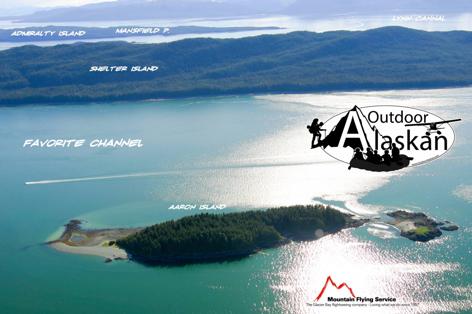
in Favorite Channel, 1.2 mi. NW of Point Stephens and 17 mi. NW of Juneau; Coast Mts. 0.4 mile long
named in 1880 by Captain L of O. J. Vanderbilt, a local miner.
Auke,
Archipelagos:Bars:Battleship Reef, Cohen Reef, Dornin Rock, Eagle Reef, Faust Rock, Favorite Reef, George Rock, Gibby Rock, Horse Shoal, Mendenhall Bar, North Ledge, Poundstone Rock, Vanderbilt Reef,
Basins:Bays:Adams Anchorage, Amalga Harbor, Auke Bay, Auke Nu Cove, Barlow Cove, Bridget Cove, Coot Cove, Crab Cove, Curlew Ledge, Eagle Harbor, Fritz Cove, Funter Bay, Halibut Cove, Hand Trollers Cove, Huffman Harbor, Indian Cove, Lena Cove, Lincoln Anchorage, Pearl Harbor, Shelter Cove, Smugglers Cove, Tee Harbor, Yankee Cove,
Beaches:Capes:Auke Cape, Barlow Point, Clear Point, Entrance Point, False Point Retreat, Indian Point, Inspiration Point, Point Lena, Point Louisa, Mansfield Peninsula, Mendenhall Peninsula, Middle Point, Outer Point, Piling Point, Point Retreat, Spaulding Point, Spuhn Point, Point Stephens, Symonds Point,
Channels:Favorite Channel, North Pass, Saginaw Channel,
Cliffs:Glaciers:Eagle Glacier, Herbert Glacier,
Hills:Islands:Aaron Island, Bare Island, Barlow Island, Battleship Island, Benjamin Island, Bird Island, Coghlan Island, Cohen Island, Colt Island, Gauge Island, Gull Island, Horse Island, Hump Island, Indian Island, Kishbrock Island, The Kittens, Ledge Island, Lincoln Island, Mab Island, Naked Island, North Island, Portland Island, Rat Island, Sentinel Island, Shaman Island, Shelter Island, Spuhn Island, Star Rock, Station Island, Strauss Rock, Suedla Island,
Lakes:Auke Lake, Peterson Lake, Salt Lake, Shelter Lake, Windfall Lake,
Mine:Admiralty Mine, Aurora Borealis Mine, Bessie Mine, Eagle River Mine, Peterson Mine, Windfall Creek Mine,
Mountains:Auke Mountain, Mount Ernest Gruening, Green Mountain, Lone Mountain, Mount Meek, Mount Robert Barron, Thane Mountain, Treasury Hill,
Parks:Auke Recreation Area, Funter Bay State Marine Park, Shelter Island State Marine Park,
Rivers:Eagle River, Herbert River, Mendenhall River,
Streams:Auke Creek, Auke Nu Creek, Bay Creek, Bear Creek, Bessie Creek, Boulder Creek, Canyon Creek, Cordwood Creek, Cove Creek, Davies Creek, Elevenmile Creek, Goose Creek, Lake Creek, Lena Creek, McGinnis Creek, Peterson Creek, Peterson Creek, Shrine Creek, Slate Creek, South Fork Cowee Creek, Tee Creek, Tenk Creek, Tusta Creek, Waydelich Creek, Windfall Creek,
Routes:Amalga Trail, Bear Creek Trail, Bessie Creek Trail, Herbert Glacier Trail, Montana Creek Trail, Peterson Creek Trail, Point Bridget Trail, Rainforest Trail, Spaulding Trail, Windfall Lake Trail, Yankee Basin Trail,
Valleys:Cities:Auke Bay, Dobson Landing, Fairhaven, Funter, Lena Beach, Saint Terese, Tee Harbor,
Pictures of, from, or near Aaron Island.
Sorted by Most Common to Least Common Viewings
Black Turnstone, Harlequin Duck, Herring Gull, Black Scoter, Pelagic Cormorant, Black Oystercatcher, White-winged Scoter, Red-necked Phalarope, Bufflehead, Bald Eagle, Marbled Murrelet, Pacific Loon, Common Raven, Dark-eyed Junco, Song Sparrow, Canada Goose, Rufous Hummingbird, Whimbrel, Greater Yellowlegs, Common Murre, Pigeon Guillemot, Iceland Gull, Belted Kingfisher, Pacific-slope Flycatcher, Steller's Jay, Swainson's Thrush, American Robin, Yellow Warbler