Thunder Bird Creek Gallery
Pictures of, from, or near Thunder Bird Creek.
flows NW to Eklutna River, 24 mi. NE of Anchorage, Cook Inlet Low.
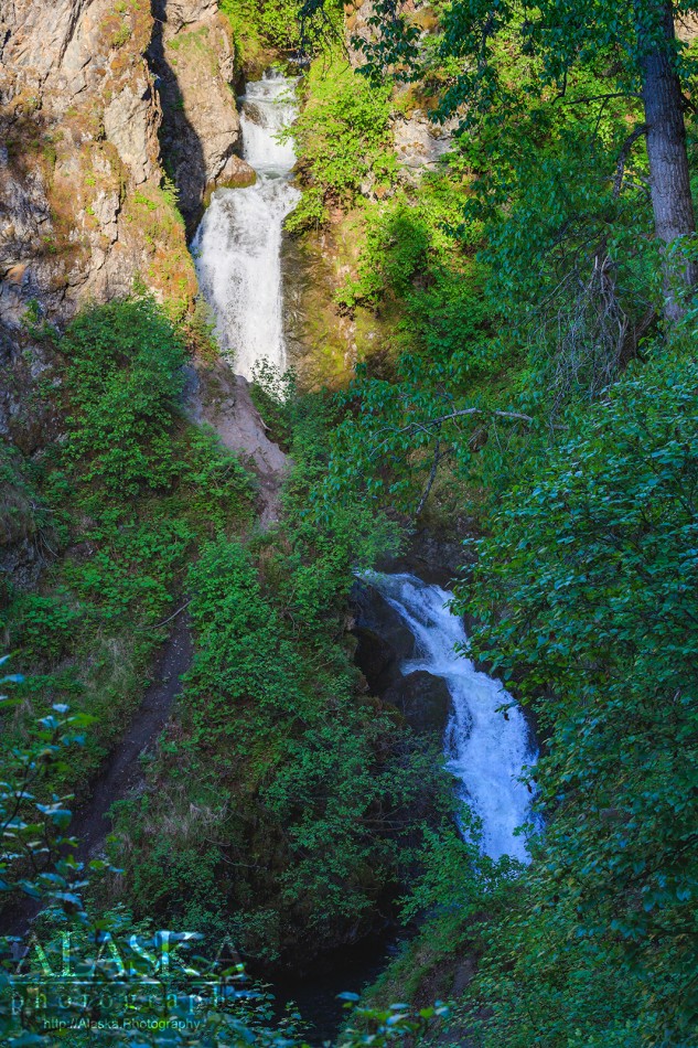
Thunder Bird Creek is a 12 mile long creek that flows out of the Chugach Mountains and feeds the Eklutna River. Along the way the creek makes a stepped drop into a canyon forming Thunder Bird Falls.
FromAnchorage take Glenn Highway about 25 miles north, take a right and exit on to Old Glenn Highway. There will be signs on the highway for Thunder Bird Falls though the sign and everything will read Thunderbird Falls.
Local name reported in 1951 by U.S. Geological Survey (USGS).Naming: Thunder Bird Creek is a local name recorded in 1951 by USGS, it acquired its name from the falls whose name was recorded 9 years prior.
Ch-atan Kaq-, Chuqilin Kaq-, Skitnu Hdakaq-,
Bays:Cities:Dams:Eklutna Dam, Lower Eklutna Dam, Memory Lake Estates Dam Number 1, Memory Lake Estates Dam Number 2,
Flats:Lakes:Anderson Lake, Baird Lake, Lake Barbara, Beach Lake, Beverly Lake, Beverly Lake, Black Lake, Bradley Lake, Bruce Lake, Canoe Lake, Chignaki Pond, Clear Lake, Cornelius Lake, Cottonwood Lake, Dandy Lake, Dinkel Lake, Dry Lake, Duck Lake, Dusk Lake, Echo Lake, Edmonds Lake, Eklutna Lake, Emerald Lake, Ezi Slough, Finger Lake, Gooding Lake, Hart Lake, High Ridge Lake, Irene Lake, Jacobsen Lake, Johnson Lake, June Lake, Kalmbach Lake, Kennedy Lake, Kepler Lake, Kings Lake, Klaire Lake, Loberg Lake, Long Lake, Lower Fire Lake, Lucile Lake, Lucy Lake, Matanuska Lake, McLeod Lake, Meier Lake, Memory Lake, Merri Belle Lake, Minor Lake, Mirror Lake, Mud Lake, Mud Lake, Mud Lake, Neklason Lake, Nik-udatl-ech-a Bena, Paradise Lake, Psalm Lake, Reed Lake, Reedy Lake, Reflections Lake, Triangle Lake, Upper Fire Lake, Walby Lake, Wallace Lake, Wasilla Lake, Weinie Lake, Wolf Lake,
Locales:3 Bowls, Cotton Grass, Dog Bowl, Koch, Leighow Moon, Lynx, Nike Chutes,
Mine:Mountains:Mount Eklutna, Mount Gordon Lyon, Highland Mountain, Little Teton Mountain, Mount Magnificent, Peeking Mountain, Mount POW/MIA, Rendezvous Peak, West Twin Peak,
Parks:Beach Lake Park, Edmonds Lake Park, Finger Lake State Recreation Site, Loretta French Park, Mirror Lake State Wayside Park, Peters Creek Community Park, Wolf Lake State Recreation Site,
Mountain Passes:Cottonwood Slough, Palmer Slough, Rabbit Slough, Spring Creek,
Peaks:Bear Mountain, Goat Rock, Gold Star Peak, Pleasant Mountain, South Raina Peak, The Nipple, Mount William Barrett,
Rivers:Eklutna River, Knik River, Matanuska River, South Fork Eagle River,
Streams:Carnegie Creek, Carol Creek, Coal Creek, Cottonwood Creek, Ezi Slough, Falling Water Creek, Fire Creek, Little Peters Creek, Meadow Creek, Mink Creek, Moon Princess Creek, Parks Creek, Peters Creek, Spring Creek, Thunder Bird Creek, Wasilla Creek,
Routes:Albert Loop Trail, Bear Point Trail, Blacktail Ptarmigan Rocks Trail, Connector 1 Trail, Dew Mound Trail, Eagle River Green Belt Trail, Eagle River North Fork Access Trail, Meadow Creek Trail, Mile High Ridge Trail, Mile High Saddle Trail, Mount Eklutna Trail, Mt Baldy Trail, Muktuk Marston Memorial Trail, Peters Valley Trail, Ptarmigan Valley Trail, Rodak Nature Loop Trail, Rondevous Peak Spur Trail, Rondevous Peak Trail, Rondevous Ridge Trail, South Fork ER Trail, Thunderbird Falls Trail,
Cities:Birchwood, Chugiak, Cottonwood, Eklutna, Gateway, Matanuska, Peters Creek, Tanaina,
Waterfalls:Pictures of, from, or near Thunder Bird Creek.