Mineral Creek Gallery
Pictures of, from, or near Mineral Creek.
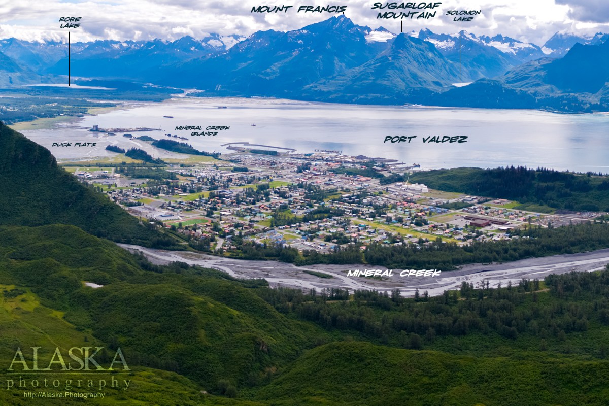
heads inn Mineral Creek Glacier, flows S to Port Valdez, 4.7 mi. NW of Valdez, Chugach Mts.
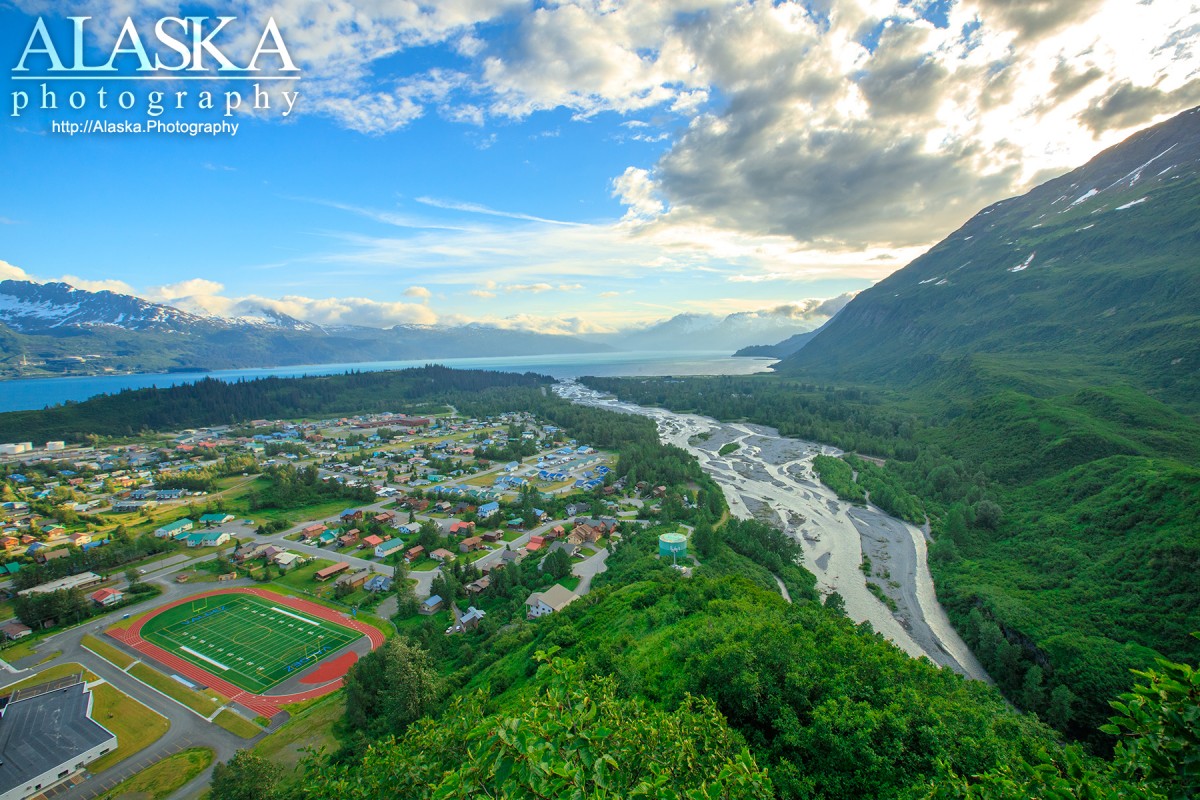
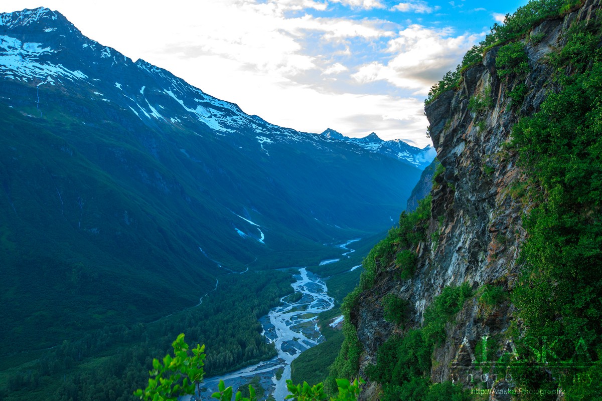
Mineral Creek is a 10 mile long creek flowing out of the Chugach Mountains from Mineral Creek Glacier, down a narrow valley, behind Valdez empting in to Port Valdez.
There is a dirt road the goes up along Mineral Creek Valley until the valley gets too narrow and the road it washed out in multiple places and the only option is on foot.
Though it is accessible by car many people hike or ATV Mineral Creek in summer and cross-country ski it in winter.
From downtown Valdez, take Egan Ave, turn towards the hill on Hazelet Ave, then left on to Hagnita St, and right on to Mineral Creek Drive. From that point travel as far as you wish.
Lower access is possible from downtown Valdez if you stay on Egan Ave (it turns into Egan Dr) and it will cross Mineral Creek.
This is presumably a local name published in 1898.Mineral Creek used to be home to mining operation up near where it heads. There are still private claims being worked along Mineral Creek. Be sure not to trespass.
| September 7, 2015 | 1 person died | atving | Read More |
Anderson Bay, Jack Bay, The Lagoon, Port Valdez, Shoup Bay,
Capes:Allison Point, Dock Point, Jackson Point,
Caves:Cities:Crags:Valdez Glacier Campground Wall, Lookout Rock, Panorama Point,
Dams:Solomon Gulch Dam A, Solomon Gulch Dam B, Solomon Lake Dam,
Flats:Glaciers:Glacier G213478E61182N, Allison Glacier, Area 51 Glacier, Glacier G213498E61160N, Glacier G213500E61175N, Glacier G213550E61021N, Glacier G213583E61167N, Glacier G213585E61165N, Glacier G213585E61165N, Glacier G213602E61200N, Glacier G213603E61218N, Glacier G213614E61180N, Glacier G213653E61264N, Glacier G213685E61168N, Glacier G213687E60954N, Glacier G213708E60993N, Glacier G213722E60985N, Glacier G213723E61170N, Glacier G213727E61240N, Glacier G213737E60948N, Glacier G213739E61247N, Glacier G213740E61167N, Glacier G213742E61233N, Glacier G213749E60966N, Glacier G213750E61221N, Glacier G213756E61212N, Glacier G213756E61263N, Glacier G213766E60924N, Glacier G213767E61200N, Glacier G213767E61245N, Glacier G213770E61226N, Glacier G213775E60940N, Glacier G213777E61166N, Glacier G213778E61174N, Glacier G213780E61222N, Glacier G213780E61222N, Glacier G213783E60980N, Glacier G213784E61033N, Glacier G213788E60991N, Glacier G213798E61012N, Glacier G213804E61037N, G-g-g-g-g Glacier, Johnson Glacier, Kate Glacier, Mineral Creek Glacier, Salmon Creek Glacier, Shoup Glacier, Valdez Glacier,
Routes:Blue Horizons, Excalibur, Gravy Tran, Kayaker's Delight, Necromancer, Peggy's Mane, Wowie Zowie,
Islands:Ammunition Island, Entrance Island, Mineral Creek Islands,
Lakes:Allison Lake, Silver Lake, Solomon Gulch Lake, Solomon Lake, Solomon Lake,
Locales:Airport Chute, Alaska Guide Company - Office, Area 51, Basin Cove, Cabell Chute, Chuck Chute, Chuck Junior, Delta Chute, Grant Chute, Jago Chute, Lookout Bowl, Lucky 13, Runner's Delight, Sentinel, Sheepshead Chute, Tombstone Wall,
Mine:Big Four Mine, Cash Mine, Giant Mine, Hercules Mine, Johnson Mine, Midas Mine,
Mountains:Mount Francis, Mount Kate, Lindita Peak, Mount Logan, Mount Hogan, Mummy Mountain, Mount Shasta, Mount Shouplina, Sugarloaf Mountain, West Peak,
Parks:Jack Bay State Marine Park, Shoup Bay State Marine Park,
Peaks:Benzene, Bob's Knob, Comstock, Embick, High Back, Mile High Peak, Snow Dome, Titan Chair,
Rivers:Duck River, Lowe River, Robe River,
Routes:Lazy Days, No Floss Necessary, Route number 1, Route number 3, Trim the Bush, Wet Finish,
Routes:Already Herd, Bicentennial, Bongo That Bitch, Brand New, Canadian Heat Wave, Cotter Unlimited, Danger Stranger, Dragon's Teeth, Dynosaur, The Firing Line, Gusel Jugs, Harristotle, Kentner's Mill, Leaf BlowersL, Ledgeway to Sleven, Lefty Lucy, People Get Up And Drive Your Funky Soul, Quartzsite's Strike, Reacharound, Redheaded Stepchild, Righty Tighty, Route number 2, Slabawooke, The Nose Knows, Your Favorite Weapon,
Streams:Abercrombie Creek, Allison Creek, Brevier Creek, Corbin Creek, Crooked Creek, Dayville Creek, East Fork Mineral Creek, Glacier Creek, Gold Creek, Gregorioff Creek, Horsetail Creek, McAllister Creek, Millard Creek, Mineral Creek, Palmer Creek, Salmon Creek, Sawmill Creek, Uno Creek, Valdez Glacier Stream, Wood Creek,
Routes:Area 51 Access Trail, Dayville Power Line Trail, Dock Point Trail, Mount Francis Winter Trail, High School Hill, High School Hill to Summit Trail, High School Hill Water Tower Trail, Hogsback Trail, Homestead Trail, Jack Bay Island Trail, John Hunter Memorial Trail, Levee to Valdez Glacier Trail, Lost Toque Trail, Mineral Creek East Trail, Mineral Creek Stamp Mill Trail, Mineral Creek West Trail, Northern Robe Lake Trail, River Drive Trail, Robe River Hogsback Access Trail, Shoup Bay Trail, Solomon Gulch Valdez Overlook Spur, Southern Robe Lake Trail, Valdez Bike Path, Valdez Overlook Trail,
Valleys:Abercrombie Gulch, Solomon Gulch,
Cities:Pictures of, from, or near Mineral Creek.