Lowe River Gallery
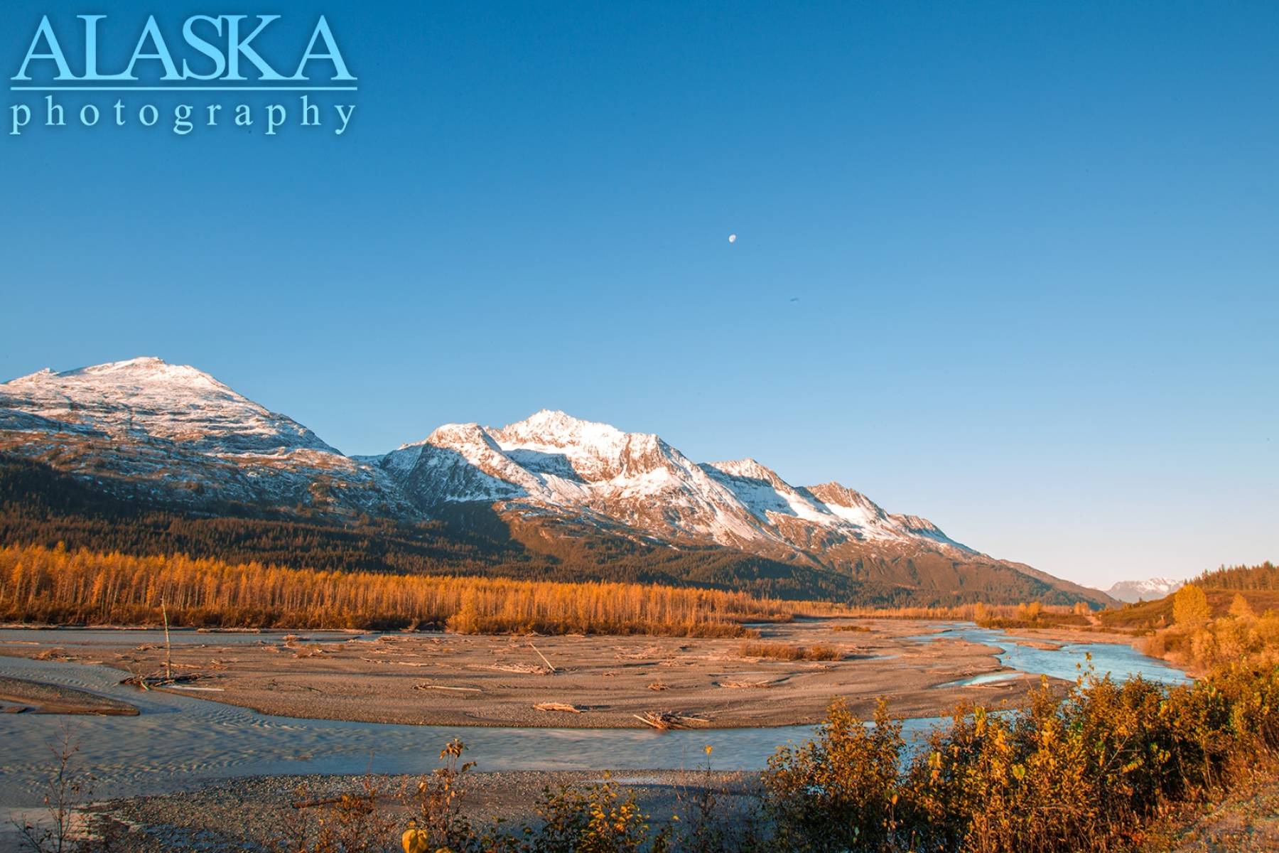
Pictures of, from, or near Lowe River.
The Lowe River heads in Marshall Pass primarily fed by Deserted Glacier about 20 miles east of Valdez. It soon flows through Heiden Canyon which is considered a Class V sections, then opens to a valley when joined by Bench Creek. It then flows mostly calm and relatively shallow for a few miles until it enters Keystone Canyon. Keystone Canyon section is considered a Class III. If floating Keystone Canyon be mindful of Killer Pillar, a section of bridge pillar that sends many people into the river which has resulted in multiple deaths. While flowing through the Keystone Canyon the river becomes swift and deep. Upon exiting the canyon it widens out and flows as a Class II braided river the remaining 12 miles where it enters Port Valdez.
Lowe River is navigable by raft, kayak, packraft, and inflatable canoe. Some areas are navigable by canoe and airboat.
Through much of winter the Lowe from Keystone Canyon back, freezes over. Past the canyon most of the river remains open and flowing but water levels are low there are many places to cross on snowmachine. That being said there are still deep pools so be mindful where you cross. In April the river clears of ice and while the glaciers remain frozen up high the water remains clear. In late May as the glaciers high up begin to melt the river turns milky grey with glacier silt.
Some salmon will run the Lowe but not large numbers. Red salmon can be found in clear springs and wetlands off the Lowe in September and October.
The Lowe River follows along the Richardson Highway near Valdez.
Naming: Named by Captain W. R. Abercrombie, USA, in 1898, for Lieutenant Percival G. Lowe, a member of his exploring party.
Allison Point, Dock Point, Jackson Point,
Cities:Crags:Valdez Glacier Campground Wall, Lookout Rock, Panorama Point,
Dams:Solomon Gulch Dam A, Solomon Gulch Dam B, Solomon Lake Dam,
Flats:Glaciers:Abercrombie Shelf Glacier, Allison Glacier, Area 51 Glacier, Camicia Glacier, Glacier G213550E61021N, Glacier G213583E61167N, Glacier G213585E61165N, Glacier G213585E61165N, Glacier G213602E61200N, Glacier G213603E61218N, Glacier G213614E61180N, Glacier G213653E61264N, Glacier G213685E61168N, Glacier G213687E60954N, Glacier G213708E60993N, Glacier G213722E60985N, Glacier G213723E61170N, Glacier G213727E61240N, Glacier G213737E60948N, Glacier G213739E61247N, Glacier G213740E61167N, Glacier G213742E61233N, Glacier G213749E60966N, Glacier G213750E61221N, Glacier G213756E61212N, Glacier G213756E61263N, Glacier G213766E60924N, Glacier G213767E61200N, Glacier G213767E61245N, Glacier G213770E61226N, Glacier G213775E60940N, Glacier G213777E61166N, Glacier G213778E61174N, Glacier G213780E61222N, Glacier G213780E61222N, Glacier G213783E60980N, Glacier G213784E61033N, Glacier G213788E60991N, Glacier G213798E61012N, Glacier G213804E61037N, Glacier G213821E60955N, Glacier G213835E60986N, Glacier G213860E61028N, Glacier G213869E60950N, Glacier G213881E61189N, Glacier G213882E60988N, Glacier G213883E61190N, Glacier G213898E61187N, Glacier G213914E60880N, Glacier G213934E61146N, Glacier G213935E61200N, Glacier G213941E60895N, Glacier G213942E60986N, Glacier G213944E60979N, Glacier G213945E60907N, Glacier G213981E61263N, G-g-g-g-g Glacier, Johnson Glacier, Kate Glacier, Mineral Creek Glacier, Salmon Creek Glacier, Silver Glacier, Valdez Glacier,
Hills:Routes:Blue Horizons, Diamond in the Sky, Excalibur, Gravy Tran, Kayaker's Delight, Necromancer, Peggy's Mane, Wowie Zowie,
Islands:Ammunition Island, Mineral Creek Islands,
Lakes:Allison Lake, Crater Lake, Deep Lake, Robe Lake, Solomon Gulch Lake, Solomon Lake, Solomon Lake, Valdez Glacier Lake,
Locales:Airport Chute, Alaska Guide Company - Office, Area 51, Basin Cove, Cabell Chute, Chuck Chute, Chuck Junior, Delta Chute, Grant Chute, Jago Chute, Lookout Bowl, Lucky 13, Runner's Delight, Sentinel, Sheepshead Chute, Tombstone Wall,
Mine:Big Four Mine, Cash Mine, Giant Mine, Hercules Mine, Johnson Mine, Midas Mine,
Mountains:Prospectors Peak, Abercrombie Mountain, Mount Denson, Mount Francis, Mount Kate, Mummy Mountain, Sugarloaf Mountain, West Peak,
Peaks:Benzene, Bob's Knob, Comstock, Embick, High Back, Mile High Peak, Snow Dome, Titan Chair,
Rivers:Routes:Lazy Days, No Floss Necessary, Route number 1, Route number 3, Trim the Bush, Wet Finish,
Routes:Already Herd, Bicentennial, Bongo That Bitch, Brand New, Canadian Heat Wave, Cotter Unlimited, Danger Stranger, Dragon's Teeth, Dynosaur, The Firing Line, Gusel Jugs, Harristotle, Kentner's Mill, Leaf BlowersL, Ledgeway to Sleven, Lefty Lucy, People Get Up And Drive Your Funky Soul, Quartzsite's Strike, Reacharound, Redheaded Stepchild, Righty Tighty, Route number 2, Slabawooke, The Nose Knows, Your Favorite Weapon,
Streams:Abercrombie Creek, Allison Creek, Brevier Creek, Cameron Creek, Camicia Creek, Canyon Slough, Corbin Creek, Crooked Creek, Dayville Creek, East Fork Mineral Creek, Glacier Creek, Goat Creek, Gold Creek, Horsetail Creek, Mineral Creek, Salmon Creek, Sawmill Creek, Slater Creek, Valdez Glacier Stream, Wood Creek,
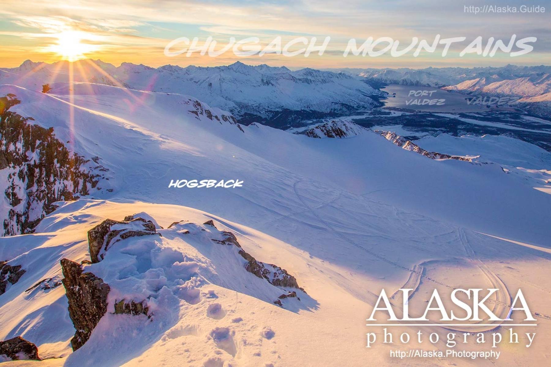
Routes:Area 51 Access Trail, Dayville Power Line Trail, Dock Point Trail, East Peak Access Trail, Mount Francis Winter Trail, High School Hill, High School Hill to Summit Trail, High School Hill Water Tower Trail, Hogsback Trail, Homestead Trail, John Hunter Memorial Trail, Levee to Valdez Glacier Trail, Lost Toque Trail, Mineral Creek East Trail, Mineral Creek Stamp Mill Trail, Mineral Creek West Trail, Northern Robe Lake Trail, River Drive Trail, Robe River Hogsback Access Trail, Shoup Bay Trail, Solomon Gulch Valdez Overlook Spur, Southern Robe Lake Trail, Valdez Bike Path, Valdez Overlook Trail,
Valleys:Abercrombie Gulch, Goat Gully, Solomon Gulch, Sulphide Gulch,
Cities:Pictures of, from, or near Lowe River.